Paddle Lunenburg/Queens
River Route 4-2: Medway River (Greenfield to below Bangs Falls)
Record #:
LQR0020
Last Modified:
11 Apr 2019
Last Full Update:
03 Jul 2014
Comments
| Public Bulletin | Neither South Shore Connect.ca nor the Lunenburg-Queens Recreational Coordinators/Directors Association own or control the canoe routes, portages or campsites listed in this guide, and assume no responsibility or liability for the safety of those using the canoe routes, walking the portages, or using the campsites. lt is recommended that users approach all canoe routes, portages and campsites in a safe and responsible manner. Conditions can change through fluctuating water levels, natural debris, and logging activity. Arrangements must be made directly with the owners of the portages and campsites. South Shore Connect.ca and Lunenburg-Queens Recreational Coordinators/Directors Association are not liable for any errors or omissions in this guide. |
Location
| Located In | South Shore Region |
| Where To Find Us | Greenfield, NS |
| Areas Served | Lunenburg County ; Queens County (NS) |
Contact
| chaughn@chester.ca | |
| Phone | 902-275-3490 |
| Contact | Chad Haughn, President, LQRCDA |
Description & Services
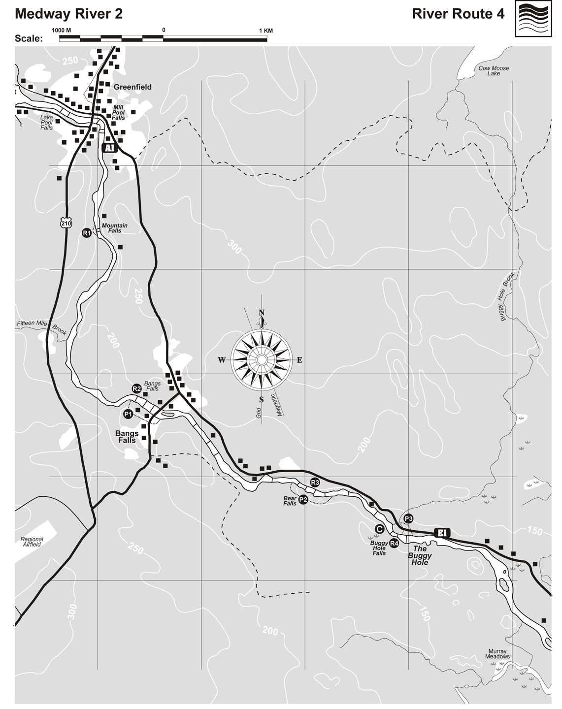
| Information |  This section of the Medway provides some of the best whitewater in Nova Scotia and is a favourite spot with local river kayakers and people in open play boats who can spend hours in one rapid. Where: Near Greenfield Skill Level: Intermediate/Expert, Rapids Class 1-4 Time: Half-day Distance: 7 km Portages: One mandatory, others optional Start: Riverview Lodge, Greenfield Mid-way Access/Exit: Bangs Falls Finish: The Buggy Hole  The rapids and falls have numerous holes and waves requiring at times advanced white water techniques (for example rolling!). It is also a good run for open canoeists with intermediate moving water experience as the portages are easy and short (all less than 200 metres). River rescue skills are also recommended. The Medway is very scenic and a popular salmon and trout river. It holds its water levels better than most Nova Scotia rivers and is often still runable when other rivers are too low. An unpaved road with numerous cottages parallels the river from Greenfield to Mill Village providing many access/exits along the route. The Journey This section has four sets of falls. Rapid 1 - Mountain Falls - Class 2-3. This rapid is about 1 km past the put-in at Riverview Lodge in Greenfield. Scout and portage from river right. The river bends to the right with large standing waves. The safest passage is river right. Just past here you’ll see another 2 km of rips and riffles. Rapid 2 - Bangs Falls - Class 2-3 The Falls are just before the Bangs Falls Bridge. Scout or portage on river right. To portage take out above the first ledge by a small boat house and put in below the bridge. If you choose to run it, stay extreme river right or in the main channel. From here to Bears Falls is a series of rips and riffles that you may want to scout in places depending on the water level and your skills. Rapid 3 - Bears Falls - Class 4. A portage (50 m river right) is mandatory for all but experts with appropriate equipment. Look for houses on the left side. If you run it, there is a quick drop through a shoot on river right that can be done if the water is high enough. This is followed by more Class 1 and 2 rips and riffles with scouting recommended. Rapid 4 - The Buggy Hole - Class 2. At this point, the river narrows and drops while bending to the left. Scouting is essential. Portage river left. A small back channel allows boats to be run part way. There is also a portage on the right hand side going over a hill if you are carrying on. If you run the rapid take out river left to get your car at E1. Water Safety Notes A plastic boat of some kind is recommended. See also River Notes for information on water levels, obstacles, skill level and rapid classification and other details relevant to river travel. Camping Above the Buggy Hole Falls is a potential campsite on river left. How to get there Exit Point 1 - Buggy Hole Falls From Bridgewater, turn north at Exit 13 off Highway 103 and travel 6.5 km. Turn left here onto Route 210 to Greenfield. Turn left at the convenience store and drive 7km downstream. Park about 100 m past the bridge just below Buggy Hole Falls on the road near a small cabin. A little further down- stream, you can also exit where the road is close to the river. A third option in this area is a small public boat ramp just below Dean Brook Bridge, river left. Access Point One - Riverview Lodge Turn left at the convenience store in Greenfield,drive .5 km and turn right down a driveway along a field. Put in where the road meets the river just before the lodge.Parking is provided at the lodge owned by Moyal Conrad .Accommodations are also available. 902-685-2378. Topographic map - Bridgewater21 A/7 and Liverpool 21 A/2 |
| Eligibility | Ages: 16 year(s) and up Children under 16 with adults - please use own discretion depending on skill level |
Special Information
| Established | 1998 |
| Tags | Canoe/Kayak ; Maps ; NS Trail Guide ; Recreation Categories ; South Shore Connect |
| Categories - General | Canoeing ; Kayaking ; Maps ; Recreational Rivers |


 Suggest an Update" at the top of the listing.