Paddle Lunenburg/Queens
River Route 4-1: Medway River (McGowan Lake to South Brookfield)
Record #:
LQR0019
Last Modified:
11 Apr 2019
Last Full Update:
04 Apr 2014
Comments
| Public Bulletin | Neither South Shore Connect.ca nor the Lunenburg-Queens Recreational Coordinators/Directors Association own or control the canoe routes, portages or campsites listed in this guide, and assume no responsibility or liability for the safety of those using the canoe routes, walking the portages, or using the campsites. lt is recommended that users approach all canoe routes, portages and campsites in a safe and responsible manner. Conditions can change through fluctuating water levels, natural debris, and logging activity. Arrangements must be made directly with the owners of the portages and campsites. South Shore Connect.ca and Lunenburg-Queens Recreational Coordinators/Directors Association are not liable for any errors or omissions in this guide. |
Location
| Located In | South Shore Region |
| Where To Find Us | South Brookfield, NS |
| Areas Served | Lunenburg County ; Queens County (NS) |
Contact
| chaughn@chester.ca | |
| Phone | 902-275-3490 |
| Contact | Chad Haughn, President, LQRCDA |
Description & Services
| Information | 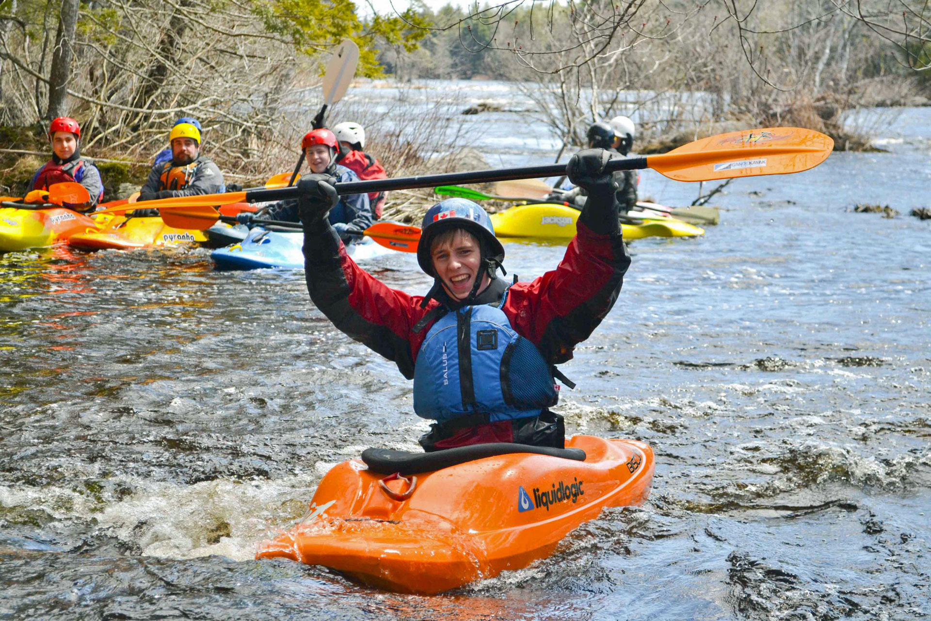 The Medway River, like the LaHave and Mersey Rivers, is a long waterway for Nova Scotia beginning far inland and flowing through many lakes. The East and West branches of the Medway are in Annapolis County and route descriptions and maps can be found here: Canoe Annapolis County Route 21 - East Branch Medway River Canoe Annapolis County Route 22 - West Branch Medway River The Medway flows into McGowan Lake and through Ponhook Lake which are both outlined in the Lake Route section. Two relatively short sections are described here with options for further travel all the way to the Atlantic. Solid intermediate skills are required. Where: Near Caledonia Skill Level: Intermediate, Rapids Class 1-3 Time: Half-day Distance: 9 km Portages: None mandatory, paddlers decision Start: Eel Lake (just below McGowan) Midway access or exit: Bridge on Westfield Road Finish: South Brookfield 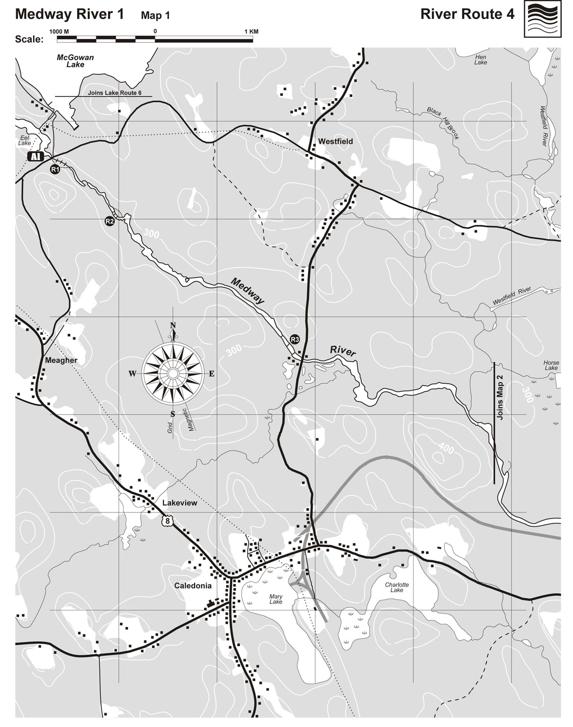 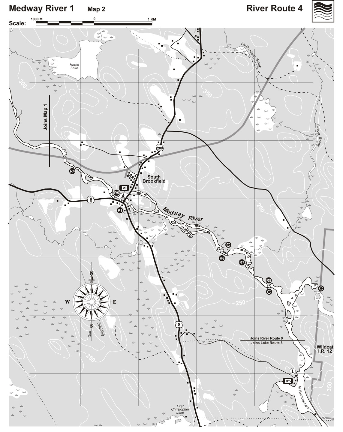 This section of the Medway has long stillwaters with exciting rapids and ledges flowing through an attractive mature forest. Little or no portaging is required. Solid intermediate skills are recommended since two of the rapids are difficult to scout beforehand with no obvious portage. This means figure it out as you go! The Journey Access Point 1 - The water starts moving at the put-in just above the bridge on Eel Lake. This is a popular spot for salmon fishing. Rapid 1 - Just below the bridge, you get immediately into a long, fun Class 2 rapid. An old logging road river right makes for easy scouting or portaging (175 m). Rapid 2 - A short distance on is Tumbling Dam, a Class 2-3 rapid that should be scouted beforehand. The portage is river left (50m). Rapid 3 - A long stillwater follows R2 and the river splits just before a long 150 m Class 2 rapid. It’s possible to go right or left (right may be easier). This rapid is hard to scout beforehand but should be OK for paddlers with intermediate skills who can manoeuvre their boat. The Westfield Road bridge is a half km further on and you can exit above or below the bridge river right. Along the next 5 km you’ll paddle through more stillwater and some rips and riffles. Rapid 4 - The next rapid is just past the railway bridge with 300m of Class 2 + water with no clear portage and or vantage points for scouting. The rapid has ledges but also distinct V’s if you know how to manoeuvre over to them . Rapid 5 - Just before Exit One (E1) at South Brookfield are a few Class 1-2 rapids. The river splits in two at E1 and goes under two bridges. Be sure to take out on the island that splits the river. Look for a red T shaped fire hydrant. Landing is easy. If you pass this point, you may be swept under the bridges and into Class 3-4 rapids. Option - South Brookfield to Echo Lodge (5km) or Ponhook Lake (7km) If you plan to go on to Echo Lodge or Ponhook Lake, you’ll need to portage to well below the bridge and rapids on river right (about 300m). To get there, exit at E1, turn right onto the pavement, cross the bridge, turn left at the stop sign and carry your boat along the road. Cross a meadow on your left just past a house to get to the river. Ask permission if possible to cross the land from the owners. The next two km is rocky with lots of islands and three short falls. All the portages are clearly visible. Rapid 6 - The first fall is next to a mature hemlock grove with a good campsite. Portage river left. The middle route is best since the left is a sluice with a rock in the middle. Rapid 7 - Two short ledges with offset passages. Scout beforehand. Run through the middle and then to the right. Rapid 8 - A sharp S-turn and drop. Portage river right. Another good campsite is here. Once past this fall, it’s a short distance and easy paddling to where the Wildcat River joins the Medway River and on down to your take out at Echo Lodge or Ponhook Lake. Up the Wildcat River a short distance is a good camping spot at the base of the Wild Cat Falls. Water Safety Notes A plastic boat of some kind is recommended. See also River Notes for information on water levels, obstacles, skill level, rapid classification and other details relevant to river travel. Points of Interest 1 - Echo Lodge (E2) - This old log building, built on a lovely spot where the river is wide and slow, dates from around 1920. The “colourful” characters who built it are described in Guides of the North Woods by Mike Parker (Page 44-46). Nevis was an American woman (no first name is given) who wanted to open a lodge and enlisted the help of local “all round woodsman” and bootlegger Jim McLeod. Jim was a tall man who liked his rum and she was a “big, hard woman.” On one occasion she beat up a Mountie and inspector after they came to check on Jim’s still. Apparently, the two were famous for their fights. Nevis would shoot at Jim or set him on fire with kerosene causing him to jump in the lake. They ran the lodge for nearly 40 years. How to get there Exit 1 - South Brookfield - This village is located where Route 8 from Liverpool meets Route 208 (from New Germany). Look for a short dirt road between the two bridges that leads to the river and a T-shaped red fire hydrant. Turn off here and park your car. Exit 2- Boat Launch just below Echo Lodge - Turn onto the Echo Lodge Road off Route 8 between Liverpool and Caledonia. This road is 2.7 kms. from South Brookfield or 2 km past the Cameron Brook Provincial Park. Drive 2.4 kms until the road splits in three. Take the middle lane and then the right lane when the road branches again. A small loop and ramp give access to the Medway River. Park off to the side so not to block other vehicles. Access Point 1 - Eel Lake Bridge From Caledonia,travel north up Route 8. About three kms from town, turn right onto Cushing Road. Go 2.4 km and turn right at the T . The bridge is another .3 km. If continuing from McGowan Lake, see McGowan Lake, Lake Route6. Connections McGowan Lake - Lake Route 6 (before Medway One) Ponhook Lake - Lake Route 8 Christopher Lakes - Lake Route 3 Medway River Two - This route - Part Two For more information - Peter Rogers, Loon Lake Outfitters 902-682-2220 Topographic map - Kejimkujik Lake 21 A/6 and Bridgewater 21 A/7 |
| Eligibility | Ages: 16 year(s) and up Children under 16 with adults - please use own discretion depending on skill level |
Special Information
| Established | 1998 |
| Tags | Canoe/Kayak ; Maps ; NS Trail Guide ; Recreation Categories ; South Shore Connect |
| Categories - General | Canoeing ; Kayaking ; Maps ; Recreational Rivers |
 Suggest an Update" at the top of the listing.